
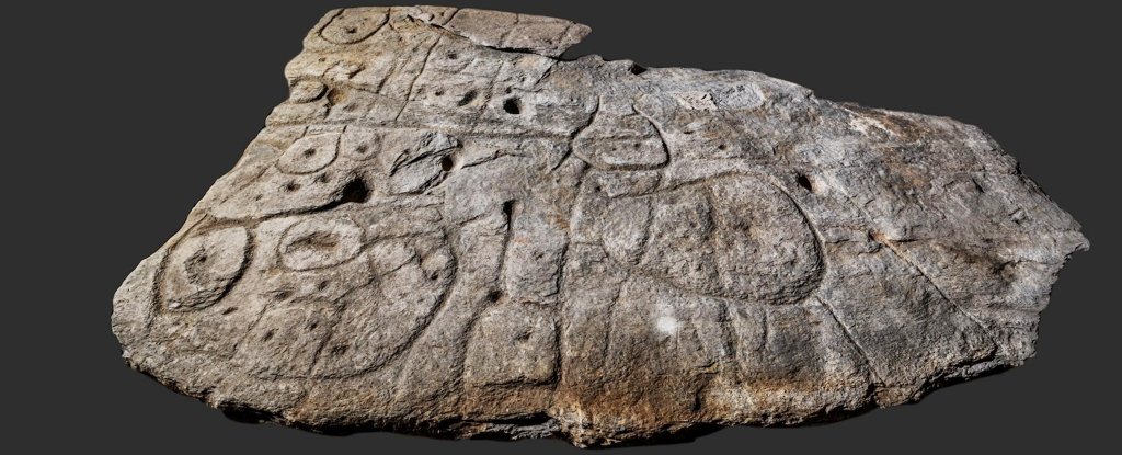
The 4m-Long Saint-Bélec Slab, First Discovered In 1900, May Be Europe’s Oldest Map, With Its Markings Depicting A Rough 3D Match To The River Region In Which The Ancient Saint-Bélec Burial Mound Existed. There Are Such Stone Map Carvings All Over The World, But This May Be The First Map, Globally, To Depict An Area On A Specific Scale.
 Forgotten Stone Slab May Actually Be The Oldest Known Map in EuropeThe markings are unfamiliar: carved contours that now only hint at a lost landscape from long ago. Nonetheless, a large, mysterious slab of stone recently rediscovered in France looks like it might just be the oldest known map in Europe.
Recent posts
- The 52 Fastest Animals in the World: Nature’s Ultimate Speed Guide January 8, 2026
- Ultimate Guide To Rainbow Colors: Order, Science, History, And More December 22, 2025
- Noise Vs. Stealth: The World’s 10 Loudest Submarines, Featuring Type 094 Submarine Operations in China December 16, 2025
- Top 17 World’s Biggest Spiders: Giants Of The Arachnid Kingdom December 11, 2025
- Murder, Pride, And Zeal: The Ultimate Guide To Group Names Of Animals December 5, 2025


